RF Geolocation & Mapping
A spectrum analyzer tells you what a signal looks like. It does not, on its own, tell you where the signal lives. RF geolocation closes that gap. It binds every measurement to a position so the answer to "is there interference here" becomes "the interference sits at this corner, on this channel, at this power." That shift from spectrum to map is what makes a field investigation tractable.
The hard part is that radio waves do not travel in clean straight lines through the real world. Buildings reflect them. Terrain blocks them. A strong multipath echo can read louder than the source you are hunting. A single power reading at a single spot means little. You need many readings, taken across a route or a grid, each one stamped with an accurate position and time, before a pattern emerges. Doing that by hand with a notebook and a clipboard is slow, error-prone, and nearly impossible to repeat. The measurement chain has to be automated, portable, and trustworthy enough that the map it produces survives scrutiny.
How the ICX-FieldHawk line solves it
The ICX-FieldHawk platform was built for exactly this kind of work. A compact real-time analyzer streams calibrated spectrum data while SpecICX-gen3 firmware ties each capture to GNSS position and timestamp. The software supports two complementary methods, and most field teams use both.
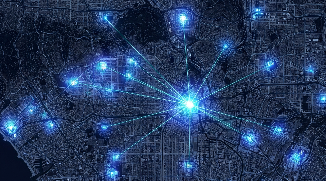
The first method is the signal-strength heat map. As the operator walks or drives a route, the system records channel power and RSSI at every point along the way, then paints those values directly onto a map as a color gradient. Hot zones glow. Coverage holes fade out. You read the source location off the brightest cluster without any further math. This approach shines when you want a broad picture fast: where a transmitter reaches, where it does not, where a noise floor climbs.
The second method is direction finding by triangulation. Using the ANT-100G directional antenna, the operator takes a bearing toward the strongest signal from one location, then moves and repeats from two or more separated positions. SpecICX-gen3 plots those bearing lines on the map, and the point where three or more lines cross marks the emitter. Triangulation cuts through multipath in dense environments where a flat heat map can mislead, and it is the method of choice when an interferer is deliberately hiding.
Both methods run on the same hardware and the same software. The system maps onto OpenStreetMap for outdoor work and accepts custom indoor floor plans for buildings, garages, and venues where satellite positioning thins out. Outputs are concrete and exportable: channel power, occupied bandwidth, and RSSI per location. Because the analyzer connects over USB and draws little power, it runs from a laptop, a tablet, or a low-power host such as a Raspberry Pi. That small footprint also makes the rig drone-deployable, so a team can lift the measurement above clutter and cover ground no vehicle can reach.
Which models and accessories fit
The right configuration depends on how the team moves and where it works.
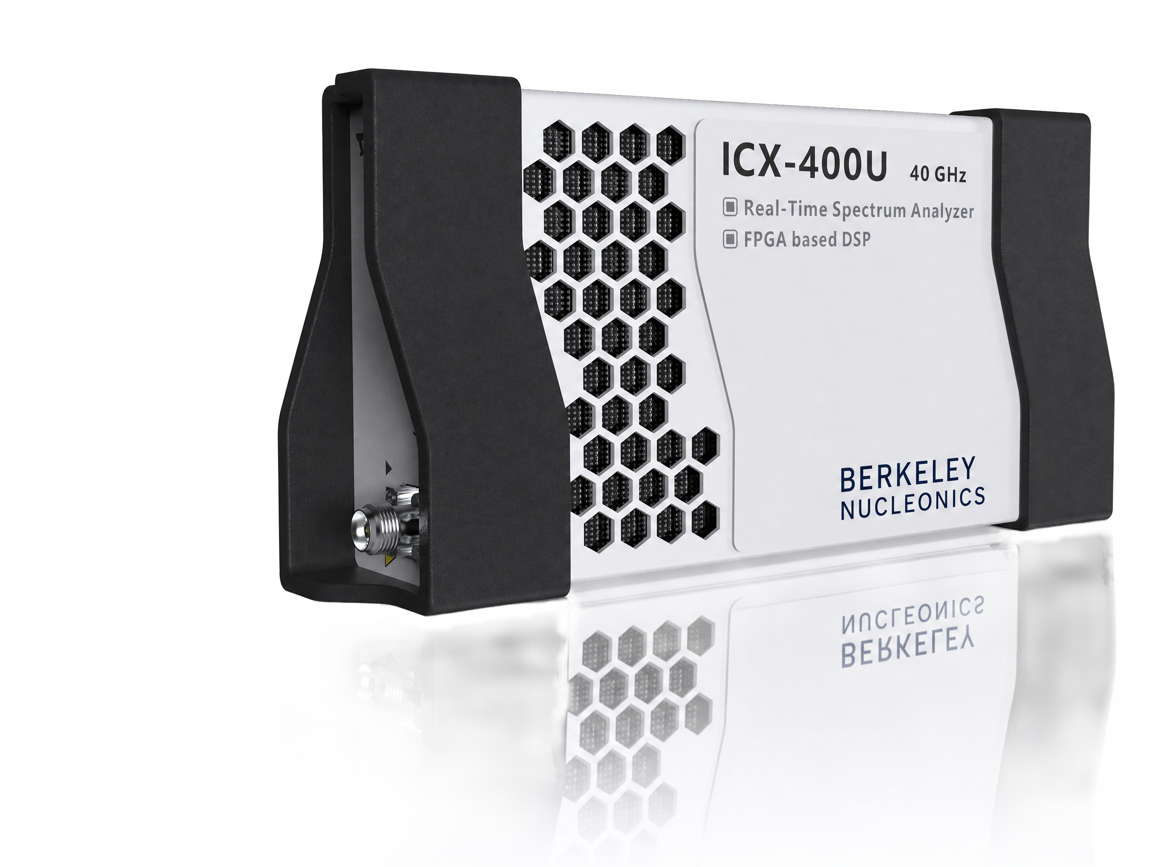
For drone payloads, embedded rigs, and Raspberry Pi hosts, the ICX-FieldHawk-U USB analyzer is the natural choice. It is light, it sips power, and it hands clean data to whatever computer you bolt it to. This is the model most teams reach for when the analyzer rides in a vehicle, hangs under a drone, or sits inside a fixed monitoring node.
For operators on foot who need a self-contained instrument with its own screen, the ICX-FieldHawk Handheld keeps the survey in one hand. No host computer, no cables to manage, no fragile setup in the rain. For field conditions that punish equipment, the ICX-FieldHawk-R Rugged variant adds environmental protection without changing the measurement workflow.
The ANT-100G directional antenna is the key accessory for any direction-finding job. It covers 500 MHz to 10 GHz and carries a switchable pre-amplifier, so it pulls in weak distant signals when the gain is on and handles strong nearby ones when the gain is off. The directionality is what makes bearings possible. Without it, triangulation has nothing to point with.
Use cases in the field
Cellular and 5G teams use mapping to validate coverage and find dead spots before customers do, turning a subjective "service feels weak here" into a measured gradient on a street map. Regulatory bodies and enforcement officers use direction finding to hunt unlicensed transmitters and run down interference complaints, then carry an exportable, position-stamped record into any dispute. Defense and TSCM teams use the same toolkit to sweep facilities for unauthorized emitters, working indoors against custom floor plans where a hidden device has nowhere to blend in.
Recommended configuration
For a flexible, do-everything geolocation kit, pair an ICX-FieldHawk-U USB analyzer with a GNSS receiver, the ANT-100G directional antenna, and SpecICX-gen3 running on a lightweight host. That single bundle handles both heat-map surveys and triangulation, mounts to a vehicle or a drone, and scales down to a Raspberry Pi for unattended or covert work. Teams that survey primarily on foot should add an ICX-FieldHawk Handheld for self-contained walk routes, and operators in harsh environments should specify the ICX-FieldHawk-R Rugged body.
To scope a kit against your terrain, host platform, and frequency targets, contact Berkeley Nucleonics at info@berkeleynucleonics.com or 800-234-7858.
For a quick question, chat with an engineer at berkeleynucleonics.com.